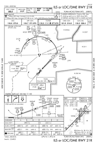
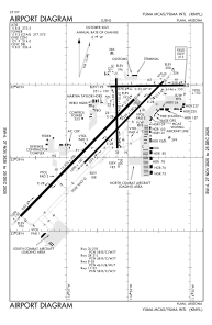


KNYL - Yuma Mcas/Yuma Intl
Located in Yuma, United States
ICAO - NYL, IATA - YUM
Data provided by AirmateGeneral information
Coordinates: N32°39'24" W114°36'22"
Elevation is 213 feet MSL.
Magnetic variation is 13° East View others Airports in Arizona
Operational data
Special qualification required
Current time UTC:
Current local time:
Weather
METAR: KNYL 161857Z 16006KT 7SM CLR 32/09 A2978 RMK AO2 SLP082 T03220089
TAF: TAF KNYL 1615/1715 16012KT 9999 FEW200 QNH2978INS BECMG 1616/1618 19008KT 9999 SKC QNH2974INS FM162100 19010KT 9999 SKC QNH2967INS TEMPO 1622/1704 18012G22KT BECMG 1707/1709 16004KT 9999 SKC QNH2975INS T36/1623Z T21/1713Z
Communications frequencies: [VIEW]
Runways:
| RWY identifier | QFU | Length (ft) | Width (ft) | Surface | LDA (ft) |
| 03L | 44° | 13300 | 200 | CONC | 13300 |
| 21R | 224° | 13300 | 200 | CONC | 13300 |
| 03R | 44° | 9240 | 150 | OTHER | 9240 |
| 21L | 224° | 9240 | 150 | OTHER | 9240 |
| 08 | 89° | 6146 | 150 | ASPH | 6146 |
| 26 | 269° | 6146 | 150 | ASPH | 6146 |
| 17 | 179° | 5710 | 150 | OTHER | 5710 |
| 35 | 359° | 5710 | 150 | OTHER | 5710 |
Airport contact information
Address: Yuma United States