


KNXP - Twentynine Palms Self
Located in Twentynine Palms, United States
ICAO - NXP, IATA -
Data provided by AirmateGeneral information
Coordinates: N34°17'46" W116°9'44"
Elevation is 2051 feet MSL.
Magnetic variation is 11° East View others Airports in California
Operational data
Special qualification required
Current time UTC:
Current local time:
Weather
METAR: KNXP 201156Z AUTO 00000KT 10SM CLR 18/06 A2997 RMK AO2 SLP114 T01830061 10228 20183 53005
TAF: TAF KNXP 2009/2109 27013KT 9999 SKC QNH2985INS BECMG 2011/2013 30006KT 9999 SKC QNH2995INS FM210130 23006KT 9999 SKC QNH2992INS T16/2013Z T32/2023Z
Communications frequencies: [VIEW]
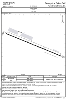
Runways:
| RWY identifier | QFU | Length (ft) | Width (ft) | Surface | LDA (ft) |
| 10 | 0° | 8015 | 150 | OTHER | |
| 28 | 0° | 8015 | 150 | OTHER |
Airport contact information
Address: Twentynine Palms United States