


KNRB - Mayport Ns (Adm David L Mcdonald Fld)
Located in Mayport, United States
ICAO - NRB, IATA -
Data provided by AirmateGeneral information
Coordinates: N30°23'29" W81°25'28"
Elevation is 14 feet MSL.
Magnetic variation is -06° East View others Airports in Florida
Operational data
Special qualification required
Current time UTC:
Current local time:
Weather
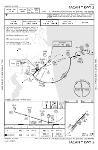
METAR: KNRB 020245Z 13013KT 3SM +RA BKN025 OVC050 24/21 A2998 RMK AO2 RAB06 T02390206 PNO $
TAF: TAF KNRB 0123/0223 14010KT 9999 VCSH FEW030 SCT120 BKN250 QNH2992INS FM020300 18006KT 9999 SCT250 QNH2994INS FM021500 10011KT 9999 SCT030 SCT250 QNH2994INS AUTOMATED SENSOR METWATCH 0104 TIL 0109 TX29/0219Z TN21/0211Z FN20021
Communications frequencies: [VIEW]
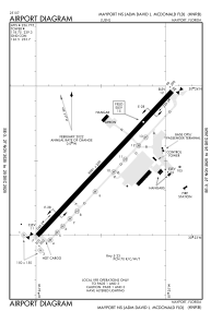
Runways:
| RWY identifier | QFU | Length (ft) | Width (ft) | Surface | LDA (ft) |
| 05 | 0° | 8001 | 200 | ASPH | |
| 23 | 0° | 8001 | 200 | ASPH |
Airport contact information
Address: Mayport United States