


KNPA - Pensacola Nas (Forrest Sherman Fld)
Located in Pensacola, United States
ICAO - NPA, IATA -
Data provided by AirmateGeneral information
Coordinates: N30°21'12" W87°19'5"
Elevation is 28 feet MSL.
Magnetic variation is -01° East View others Airports in Florida
Operational data
Special qualification required
Current time UTC:
Current local time:
Weather
TAF: TAF KNPA 0123/0223 18008KT 9999 FEW005 FEW030 SCT110 QNH2990INS FM020100 VRB04KT 9999 FEW007 QNH2992INS TEMPO 0203/0206 BKN007 FM020600 00000KT 6000 BR SCT005 QNH2991INS TEMPO 0207/0212 1600 BR BKN004 FM021300 12005KT 9999 SCT010 BKN250 QNH2995INS FM021800 19010KT 9999 SCT030 BKN250 QNH2989INS AUTOMATED SENSOR METWATCH 0203 TIL 0211 TX29/0221Z TN21/0212Z FN20034
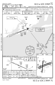
Communications frequencies: [VIEW]
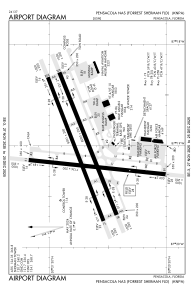
Runways:
| RWY identifier | QFU | Length (ft) | Width (ft) | Surface | LDA (ft) |
| 01 | 0° | 7136 | 200 | ASPH | |
| 19 | 0° | 7136 | 200 | ASPH | |
| 07L | 0° | 8001 | 200 | ASPH | |
| 25R | 0° | 8001 | 200 | ASPH | |
| 07R | 0° | 8000 | 200 | ASPH | |
| 25L | 0° | 8000 | 200 | ASPH |
Airport contact information
Address: Pensacola United States