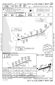
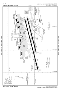


KNKX - Miramar Mcas (Joe Foss Fld)
Located in San Diego, United States
ICAO - NKX, IATA -
Data provided by AirmateGeneral information
Coordinates: N32°52'7" W117°8'35"
Elevation is 477 feet MSL.
Magnetic variation is 12° East View others Airports in California
Operational data
Special qualification required
Current time UTC:
Current local time:
Weather
METAR: KNKX 271155Z 00000KT 6SM BR BKN018 OVC033 12/12 A2992 RMK AO2 SLP128 60000 70001 T01170117 10122 20100 55001
TAF: TAF KNKX 2703/2803 25011KT 9999 BKN015 BKN020 540203 520509 521401 522209 523108 QNH2988INS BECMG 2710/2712 VRB06KT 9999 BKN020 BKN030 540203 520509 521401 522209 523108 QNH2988INS FM271730 22006KT 9999 SCT030 540203 520509 521401 522209 523108 QNH2997INS FM272030 25010KT 9999 FEW030 540203 520509 521401 522209 523108 QNH2996INS T11/2713Z T18/2721Z
Communications frequencies: [VIEW]
Runways:
| RWY identifier | QFU | Length (ft) | Width (ft) | Surface | LDA (ft) |
| 06R | 75° | 8001 | 200 | OTHER | |
| 24L | 255° | 8001 | 200 | OTHER | |
| 06L | 75° | 12000 | 200 | CONC | |
| 24R | 255° | 12000 | 200 | CONC |
Airport contact information
Address: San Diego United States