


KNKT - Cherry Point Mcas (Cunningham Fld)
Located in Cherry Point, United States
ICAO - NKT, IATA -
Data provided by AirmateGeneral information
Coordinates: N34°54'11" W76°52'51"
Elevation is 29 feet MSL.
Magnetic variation is -09° East View others Airports in North Carolina
Operational data
Special qualification required
Current time UTC:
Current local time:
Weather
TAF: TAF KNKT 1500/1521 14014KT 8000 -RA BR BKN015 OVC030 641309 642206 522409 523307 QNH2977INS TEMPO 1500/1502 15018G25KT FM150200 21010KT 9999 NSW BKN015 OVC020 641309 642206 522409 523307 QNH2968INS TEMPO 1505/1511 1000 FG FM151400 24012KT 9999 SCT020 600000 500000 QNH2961INS TEMPO 1514/1520 2400 -RA BR BKN020 T19/1506Z T26/1518Z AMD 0034
Communications frequencies: [VIEW]
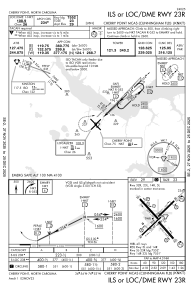
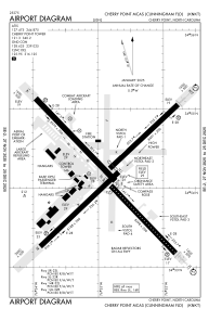
Runways:
| RWY identifier | QFU | Length (ft) | Width (ft) | Surface | LDA (ft) |
| 05L | 45° | 8489 | 196 | ASPH | 7554 |
| 23R | 225° | 8489 | 196 | ASPH | 7554 |
| 05R | 45° | 8189 | 200 | ASPH | |
| 23L | 225° | 8189 | 200 | ASPH | |
| 14L | 136° | 8978 | 200 | ASPH | |
| 32R | 316° | 8978 | 200 | ASPH | |
| 14R | 136° | 8397 | 200 | ASPH | 7549 |
| 32L | 316° | 8397 | 200 | ASPH | 7549 |
Airport contact information
Address: Cherry Point United States