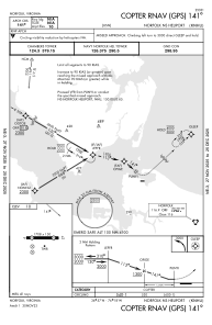


KNHU - Norfolk Ns
Located in Norfolk, United States
ICAO - NHU, IATA -
Data provided by AirmateGeneral information
Coordinates: N36°57'20" W76°18'14"
Elevation is 10 feet MSL.
Magnetic variation is -10° East View others Airports in Virginia
Operational data
Special qualification required
Current time UTC:
Current local time:
Weather at : KNGU - Norfolk Ns (Chambers Fld) ( 2 km )
METAR: KNGU 280859Z 22007KT 8SM FEW040 FEW120 21/19 A2984 RMK AO2 SLP103 T02110194 53008
TAF: TAF KNGU 2807/2907 24010KT 9000 BR FEW040 SCT120 QNH2976INS FM280900 VRB06KT 9999 FEW080 FEW150 QNH2981INS FM281900 22005KT 9999 VCSH FEW030 FEW060 QNH2977INS BECMG 2904/2906 31010KT 9999 FEW040 FEW070 QNH2983INS TX28/2821Z TN21/2809Z FN00268
Communications frequencies: [VIEW]
Runways:
| RWY identifier | QFU | Length (ft) | Width (ft) | Surface | LDA (ft) |
| 09 | 86° | 1705 | 150 | ASPH | |
| 27 | 266° | 1705 | 150 | ASPH | |
| H1 | 0° | 0 | 0 | UNK | |
| H2 | 0° | 0 | 0 | UNK | |
| H3 | 0° | 0 | 0 | UNK | |
| H4 | 0° | 0 | 0 | UNK | |
| H5 | 0° | 0 | 0 | UNK | |
| H6 | 0° | 0 | 0 | UNK | |
| H7 | 0° | 0 | 0 | UNK | |
| H8 | 0° | 0 | 0 | UNK | |
| H9 | 0° | 0 | 0 | UNK |
Airport contact information
Address: Norfolk United States