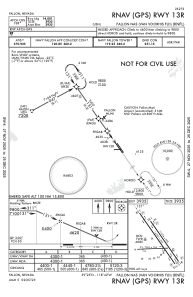
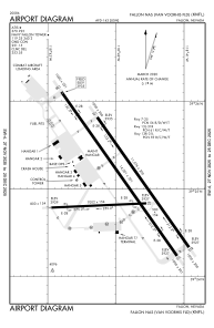


KNFL - Fallon Nas (Van Voorhis Fld)
Located in Fallon, United States
ICAO - NFL, IATA -
Data provided by AirmateGeneral information
Coordinates: N39°25'4" W118°41'55"
Elevation is 3934 feet MSL.
Magnetic variation is 14° East View others Airports in Nevada
Operational data
Special qualification required
Current time UTC:
Current local time:
Weather
METAR: KNFL 271956Z VRB05KT 10SM SCT050 SCT120 SCT250 16/M01 A3002 RMK AO2 SLP134 T01561011
TAF: TAF KNFL 2715/2815 31010KT 9999 FEW050 520405 QNH2990INS BECMG 2800/2802 33012G20KT 9999 SCT050 BKN090 640905 540905 QNH2987INS TEMPO 2804/2810 31015G25KT LAST NO AMDS AFT 2715 TIL 2907 TX18/2723Z TN03/2813Z FS30201
Communications frequencies: [VIEW]
Runways:
| RWY identifier | QFU | Length (ft) | Width (ft) | Surface | LDA (ft) |
| 07 | 88° | 7003 | 152 | ASPH | |
| 25 | 268° | 7003 | 152 | ASPH | |
| 13R | 145° | 14001 | 201 | ASPH | |
| 31L | 325° | 14001 | 201 | ASPH | |
| 13L | 145° | 11076 | 200 | CONC | |
| 31R | 325° | 11076 | 200 | CONC |
Airport contact information
Address: Fallon United States