


KNFE - Fentress Nalf
Located in Fentress, United States
ICAO - NFE, IATA -
Data provided by AirmateGeneral information
Coordinates: N36°41'31" W76°8'4"
Elevation is 16 feet MSL.
Magnetic variation is -09° East View others Airports in Virginia
Operational data
Special qualification required
Current time UTC:
Current local time:
Weather
METAR: KNFE 270856Z AUTO 08004KT 10SM OVC095 12/07 A3042 RMK AO2 SLP303 T01220072 57002
Communications frequencies: [VIEW]
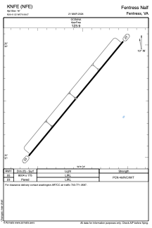
Runways:
| RWY identifier | QFU | Length (ft) | Width (ft) | Surface | LDA (ft) |
| 05 | 40° | 8004 | 175 | ASPH | |
| 23 | 219° | 8004 | 175 | ASPH |
Airport contact information
Address: Fentress United States