


KMXF - Maxwell Afb
Located in Montgomery, United States
ICAO - MXF, IATA -
Data provided by AirmateGeneral information
Coordinates: N32°22'59" W86°21'57"
Elevation is 170 feet MSL.
Magnetic variation is -02° East View others Airports in Alabama
Operational data
Special qualification required
Current time UTC:
Current local time:
Weather
METAR: KMXF 271255Z AUTO 08006KT 10SM CLR 21/15 A3022 RMK AO2 SLP235 T02060149
TAF: TAF KMXF 271100Z 2711/2817 12006KT 9999 FEW030 510043 QNH3012INS BECMG 2714/2715 13015G20KT 9999 FEW019 510043 QNH3013INS BECMG 2723/2724 14009KT 9999 SCT045 510043 QNH3014INS BECMG 2803/2804 12006KT 9999 BKN026 510043 QNH3011INS BECMG 2813/2814 14015G20KT 9000 BR SCT011 510043 QNH3016INS TX26/2720Z TN18/2712Z
Communications frequencies: [VIEW]
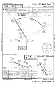
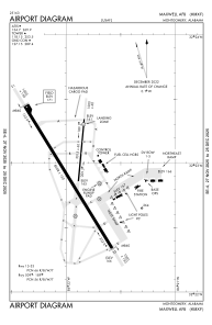
Runways:
| RWY identifier | QFU | Length (ft) | Width (ft) | Surface | LDA (ft) |
| 15 | 148° | 8008 | 150 | ASPH | |
| 33 | 328° | 8008 | 150 | ASPH | |
| 009 | 0° | 3015 | 60 | ASPH | |
| 189 | 0° | 3015 | 60 | ASPH |
Airport contact information
Address: Montgomery United States