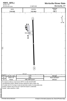


KMVL - Morrisville-Stowe State
Located in Morrisville, United States
ICAO - MVL, IATA - MVL
Data provided by AirmateGeneral information
Coordinates: N44°32'4" W72°36'50"
Elevation is 732 feet MSL.
Magnetic variation is -16° East View others Airports in Vermont
Operational data
Special qualification required
Current time UTC:
Current local time:
Weather
METAR: KMVL 290054Z AUTO 34003KT 2 1/2SM +RA BR FEW003 BKN028 OVC035 14/13 A2999 RMK AO2 RAB18 SLP159 P0005 T01440133
Communications frequencies: [VIEW]
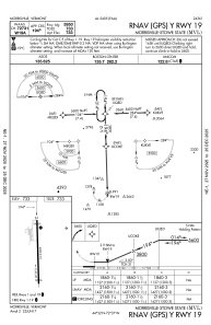
Runways:
| RWY identifier | QFU | Length (ft) | Width (ft) | Surface | LDA (ft) |
| 01 | 358° | 3700 | 75 | ASPH | |
| 19 | 178° | 3700 | 75 | ASPH |
Airport contact information
Address: Morrisville United States
