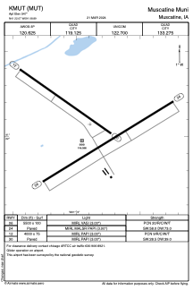


KMUT - Muscatine Muni
Located in Muscatine, United States
ICAO - MUT, IATA -
Data provided by AirmateGeneral information
Coordinates: N41°22'4" W91°8'54"
Elevation is 547 feet MSL.
Magnetic variation is -01° East View others Airports in Iowa
Operational data
Special qualification required
Current time UTC:
Current local time:
Weather
METAR: KMUT 192255Z AUTO 29018G23KT 10SM CLR 14/M03 A3015 RMK AO2
Communications frequencies: [VIEW]
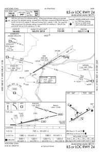
Runways:
| RWY identifier | QFU | Length (ft) | Width (ft) | Surface | LDA (ft) |
| 06 | 58° | 5500 | 100 | CONC | |
| 24 | 239° | 5500 | 100 | CONC | |
| 12 | 125° | 4000 | 75 | CONC | |
| 30 | 305° | 4000 | 75 | CONC |
Airport contact information
Address: Muscatine United States
