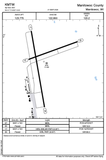


KMTW - Manitowoc County
Located in Manitowoc, United States
ICAO - MTW, IATA -
Data provided by AirmateGeneral information
Coordinates: N44°7'44" W87°40'50"
Elevation is 650 feet MSL.
Magnetic variation is -02° East View others Airports in Wisconsin
Operational data
Special qualification required
Current time UTC:
Current local time:
Weather
METAR: KMTW 211456Z AUTO 15007KT 9SM BKN003 13/12 A2987 RMK AO2 SLP114 T01280117 50000
TAF: KMTW 211518Z 2115/2212 VRB04KT 6SM BR BKN003 FM211800 12009KT P6SM VCSH SCT007 BKN020 TEMPO 2118/2121 -TSRA BKN020CB FM212100 12011G18KT P6SM VCSH SCT010 BKN050 WS020/17040KT TEMPO 2201/2204 2SM TSRA BKN012CB FM220600 20015G24KT P6SM BKN035 WS020/22050KT
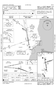
Communications frequencies: [VIEW]
Runways:
| RWY identifier | QFU | Length (ft) | Width (ft) | Surface | LDA (ft) |
| 07 | 70° | 3341 | 100 | ASPH | |
| 25 | 250° | 3341 | 100 | ASPH | |
| 17 | 170° | 5001 | 100 | ASPH | |
| 35 | 350° | 5001 | 100 | ASPH |
Airport contact information
Address: Manitowoc United States
