


KMTO - Coles County Meml
Located in Mattoon/Charleston, United States
ICAO - MTO, IATA -
Data provided by AirmateGeneral information
Coordinates: N39°28'40" W88°16'48"
Elevation is 722 feet MSL.
Magnetic variation is -03° East View others Airports in Illinois
Operational data
Special qualification required
Current time UTC:
Current local time:
Weather
METAR: KMTO 290853Z AUTO 20010G17KT 10SM TS FEW020 SCT026 OVC043 18/17 A2985 RMK AO2 LTG DSNT W-NE RAB12E49 TSB29 SLP102 P0000 60000 T01830172 55005 $
Communications frequencies: [VIEW]
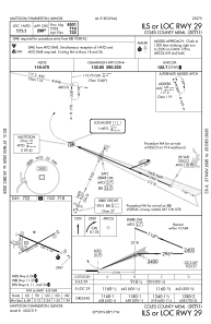
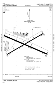
Runways:
| RWY identifier | QFU | Length (ft) | Width (ft) | Surface | LDA (ft) |
| 06 | 60° | 5799 | 100 | ASPH | 5799 |
| 24 | 240° | 5799 | 100 | ASPH | 5799 |
| 11 | 113° | 6501 | 150 | ASPH | 6501 |
| 29 | 293° | 6501 | 150 | ASPH | 6501 |
| 18 | 175° | 1098 | 250 | GRASS | 1080 |
| 36 | 355° | 1098 | 250 | GRASS | 1080 |
Airport contact information
Address: Mattoon/Charleston United States