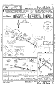
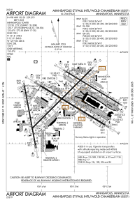


KMSP - Minneapolis-St Paul Intl/Wold-Chamberlain
Located in Minneapolis, United States
ICAO - MSP, IATA - MSP
Data provided by AirmateGeneral information
Coordinates: N44°52'55" W93°13'18"
Elevation is 841 feet MSL.
Magnetic variation is 00° East View others Airports in Minnesota
Operational data
Special qualification required
Current time UTC:
Current local time:
Weather
METAR: KMSP 291753Z 23009KT 1 3/4SM R30L/6000VP6000FT -RA BR OVC008 09/08 A2968 RMK AO2 TWR VIS 2 DZB13E44RAB44 SLP054 P0001 60006 T00940083 10100 20072 52006
TAF: KMSP 291740Z 2918/3024 21011KT 3SM -DZ BR OVC009 FM292000 27012G20KT P6SM OVC015 FM300100 27009KT P6SM OVC015 FM301000 25005KT P6SM BKN025 FM301300 18007KT P6SM BKN150 FM301800 15008KT P6SM SCT150 PROB30 3022/3024 -TSRA BKN040CB
Communications frequencies: [VIEW]
Runways:
| RWY identifier | QFU | Length (ft) | Width (ft) | Surface | LDA (ft) |
| 04 | 45° | 11006 | 150 | CONC | 9456 |
| 22 | 225° | 11006 | 150 | CONC | 10006 |
| 12L | 121° | 8200 | 150 | CONC | 7620 |
| 30R | 301° | 8200 | 150 | CONC | 8000 |
| 12R | 121° | 10000 | 200 | CONC | 10000 |
| 30L | 301° | 10000 | 200 | CONC | 10000 |
| 17 | 170° | 8000 | 150 | CONC | 8000 |
| 35 | 350° | 8000 | 150 | CONC | 8000 |
Airport contact information
Address: Minneapolis United States
