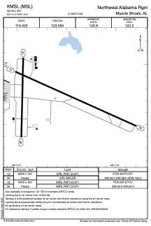


KMSL - Northwest Alabama Rgnl
Located in Muscle Shoals, United States
ICAO - MSL, IATA - MSL
Data provided by AirmateGeneral information
Coordinates: N34°44'43" W87°36'37"
Elevation is 550 feet MSL.
Magnetic variation is -03° East View others Airports in Alabama
Operational data
Special qualification required
Current time UTC:
Current local time:
Weather
METAR: KMSL 010553Z AUTO 00000KT 10SM CLR 17/16 A2998 RMK AO2 SLP147 T01670156 10261 20161 402780161 50015
TAF: KMSL 010520Z 0106/0206 VRB03KT P6SM SKC
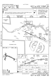
Communications frequencies: [VIEW]
Runways:
| RWY identifier | QFU | Length (ft) | Width (ft) | Surface | LDA (ft) |
| 12 | 114° | 6694 | 150 | ASPH | |
| 30 | 294° | 6694 | 150 | ASPH | |
| 18 | 181° | 4000 | 100 | ASPH | |
| 36 | 1° | 4000 | 100 | ASPH |
Airport contact information
Address: Muscle Shoals United States