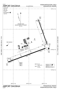


KMQJ - Indianapolis Rgnl
Located in Indianapolis, United States
ICAO - MQJ, IATA -
Data provided by AirmateGeneral information
Coordinates: N39°50'35" W85°53'52"
Elevation is 862 feet MSL.
Magnetic variation is -02° East View others Airports in Indiana
Operational data
Special qualification required
Current time UTC:
Current local time:
Weather
METAR: KMQJ 141335Z AUTO 12007KT 10SM OVC010 17/15 A2982 RMK AO2 CIG 009V013 T01680155
Communications frequencies: [VIEW]
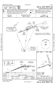
Runways:
| RWY identifier | QFU | Length (ft) | Width (ft) | Surface | LDA (ft) |
| 07 | 70° | 6005 | 100 | ASPH | |
| 25 | 250° | 6005 | 100 | ASPH | |
| 16 | 160° | 3902 | 75 | CONC | |
| 34 | 340° | 3902 | 75 | CONC |
Airport contact information
Address: Indianapolis United States

