


KMOB - Mobile Rgnl
Located in Mobile, United States
ICAO - MOB, IATA - MOB
Data provided by AirmateGeneral information
Coordinates: N30°41'29" W88°14'34"
Elevation is 218 feet MSL.
Magnetic variation is -03° East View others Airports in Alabama
Operational data
Special qualification required
Current time UTC:
Current local time:
Weather
METAR: KMOB 272156Z 12014KT 10SM FEW035 BKN100 27/16 A3014 RMK AO2 SLP203 T02670161
TAF: KMOB 271727Z 2718/2818 13017G25KT P6SM BKN025 BKN100 FM272000 14018G25KT P6SM FEW025 BKN100 FM280200 12011KT P6SM SCT050 SCT250
Communications frequencies: [VIEW]
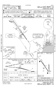
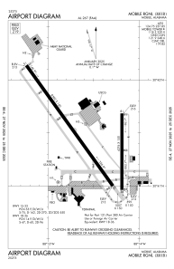
Runways:
| RWY identifier | QFU | Length (ft) | Width (ft) | Surface | LDA (ft) |
| 15 | 144° | 8502 | 150 | ASPH | |
| 33 | 324° | 8502 | 150 | ASPH | |
| 18 | 180° | 4376 | 150 | ASPH | |
| 36 | 360° | 4376 | 150 | ASPH |
Airport contact information
Address: Mobile United States

