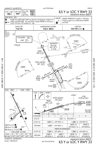


KMKT - Mankato Rgnl
Situé à Mankato, United States
ICAO - MKT, IATA -
Données fournies par AirmateInformation générale
Coordonnées: N44°13'22" W93°55'10"
Élévation : 1020 feet MSL.
Variation magnétique : 00° East Voir autres Aéroports à Minnesota
Données opérationnelles
Special qualification required
Heure actuelle UTC:
Heure actuelle locale:
Météo
METAR: KMKT 081156Z AUTO 07007KT 10SM CLR 11/08 A2964 RMK AO2 SLP038 70006 T01110083 10122 20089 53010
TAF: KMKT 081120Z 0812/0912 10009KT P6SM SCT100 FM082200 02008KT P6SM SCT060 BKN100 PROB30 0822/0904 3SM -TSRA BR BKN050CB
Fréquences de communication: [VIEW]
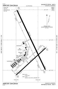
Pistes:
| Identifiant RWY | QFU | Longueur (ft) | Largeur (ft) | Surface | LDA (ft) |
| 04 | 47° | 4000 | 75 | ASPH | |
| 22 | 227° | 4000 | 75 | ASPH | |
| 15 | 155° | 6600 | 100 | CONC | |
| 33 | 335° | 6600 | 100 | CONC |
Coordonnées de l'aéroport
Adresse: Mankato United States

