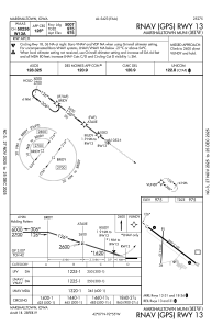
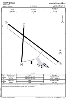


KMIW - Marshalltown Muni
Located in Marshalltown, United States
ICAO - MIW, IATA -
Data provided by AirmateGeneral information
Coordinates: N42°6'46" W92°55'4"
Elevation is 974 feet MSL.
Magnetic variation is 01° East View others Airports in Iowa
Operational data
Special qualification required
Current time UTC:
Current local time:
Weather
METAR: KMIW 290053Z AUTO 19006KT 8SM -RA SCT009 BKN015 OVC030 17/16 A2974 RMK AO2 RAB03 SLP070 P0027 T01720161
Communications frequencies: [VIEW]
Runways:
| RWY identifier | QFU | Length (ft) | Width (ft) | Surface | LDA (ft) |
| 13 | 127° | 5007 | 100 | ASPH | |
| 31 | 307° | 5007 | 100 | ASPH | |
| 18 | 184° | 2759 | 50 | ASPH | |
| 36 | 4° | 2759 | 50 | ASPH |
Airport contact information
Address: Marshalltown United States
