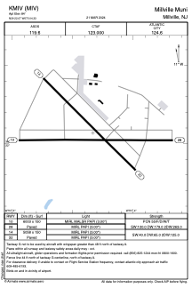


KMIV - Millville Muni
Located in Millville, United States
ICAO - MIV, IATA -
Data provided by AirmateGeneral information
Coordinates: N39°22'4" W75°4'20"
Elevation is 84 feet MSL.
Magnetic variation is -11° East View others Airports in New Jersey
Operational data
Special qualification required
Current time UTC:
Current local time:
Weather
METAR: KMIV 300854Z AUTO 00000KT 10SM CLR 18/14 A2990 RMK AO2 SLP124 T01830144 56006
TAF: KMIV 300532Z 3006/0106 VRB02KT P6SM FEW010 FM301300 22008KT P6SM SCT250 FM010300 VRB03KT P6SM BKN050
Communications frequencies: [VIEW]
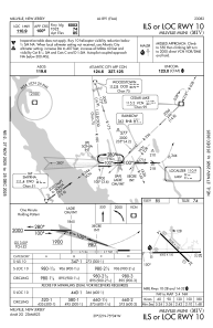
Runways:
| RWY identifier | QFU | Length (ft) | Width (ft) | Surface | LDA (ft) |
| 10 | 90° | 6003 | 150 | ASPH | |
| 28 | 270° | 6003 | 150 | ASPH | |
| 14 | 135° | 5058 | 150 | CONC | |
| 32 | 315° | 5058 | 150 | CONC |
Airport contact information
Address: Millville United States
