


KMIC - Crystal
Located in Minneapolis, United States
ICAO - MIC, IATA -
Data provided by AirmateGeneral information
Coordinates: N45°3'45" W93°21'14"
Elevation is 869 feet MSL.
Magnetic variation is 02° East View others Airports in Minnesota
Operational data
Special qualification required
Current time UTC:
Current local time:
Weather
METAR: KMIC 291653Z 00000KT 1 1/2SM BR OVC004 09/08 A2966 RMK AO2 SLP048 P0001 T00940083
Communications frequencies: [VIEW]
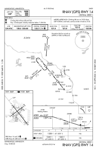
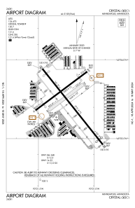
Runways:
| RWY identifier | QFU | Length (ft) | Width (ft) | Surface | LDA (ft) |
| 06L | 53° | 2500 | 75 | ASPH | 2110 |
| 24R | 233° | 2500 | 75 | ASPH | 2111 |
| 06R | 53° | 1669 | 137 | GRASS | |
| 24L | 233° | 1669 | 137 | GRASS | |
| 14 | 141° | 3751 | 75 | ASPH | 3508 |
| 32 | 321° | 3751 | 75 | ASPH | 3509 |
Airport contact information
Address: Minneapolis United States
