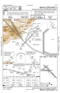
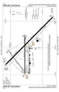


KMHV - Mojave Air&Space Port/Rutan Fld
Located in Mojave, United States
ICAO - MHV, IATA - MHV
Data provided by AirmateGeneral information
Coordinates: N35°3'32" W118°9'2"
Elevation is 2801 feet MSL.
Magnetic variation is 14° East View others Airports in California
Operational data
Special qualification required
Current time UTC:
Current local time:
Weather
METAR: KMHV 160940Z AUTO 00000KT 10SM CLR 06/02 A3008 RMK AO2
Communications frequencies: [VIEW]
Runways:
| RWY identifier | QFU | Length (ft) | Width (ft) | Surface | LDA (ft) |
| 04 | 52° | 4747 | 60 | ASPH | |
| 22 | 232° | 4747 | 60 | ASPH | |
| 08 | 90° | 7049 | 100 | ASPH | |
| 26 | 270° | 7049 | 100 | ASPH | |
| 12 | 135° | 12503 | 200 | ASPH | |
| 30 | 315° | 12503 | 200 | ASPH |
Airport contact information
Address: Mojave United States

