


KMHP - John Edwin Jones Sr Fld/Metter Muni
Located in Metter, United States
ICAO - MHP, IATA -
Data provided by AirmateGeneral information
Coordinates: N32°22'26" W82°4'53"
Elevation is 197 feet MSL.
Magnetic variation is -07° East View others Airports in Georgia
Operational data
Special qualification required
Current time UTC:
Current local time:
Weather
METAR: KMHP 151515Z AUTO 26009G16KT 10SM SCT030 BKN036 BKN043 28/19 A2977 RMK AO2 T02770193
Communications frequencies: [VIEW]
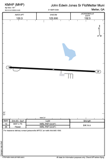
Runways:
| RWY identifier | QFU | Length (ft) | Width (ft) | Surface | LDA (ft) |
| 10 | 93° | 5001 | 75 | ASPH | |
| 28 | 273° | 5001 | 75 | ASPH |
Airport contact information
Address: Metter United States