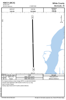


KMCX - White County
Located in Monticello, United States
ICAO - MCX, IATA -
Data provided by AirmateGeneral information
Coordinates: N40°42'37" W86°46'0"
Elevation is 678 feet MSL.
Magnetic variation is -03° East View others Airports in Indiana
Operational data
Special qualification required
Current time UTC:
Current local time:
Weather
METAR: KMCX 291535Z AUTO 19008KT 10SM -RA SCT032 SCT050 BKN110 17/16 A2991 RMK AO2 T01730155
Communications frequencies: [VIEW]
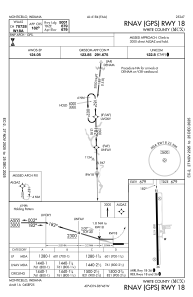
Runways:
| RWY identifier | QFU | Length (ft) | Width (ft) | Surface | LDA (ft) |
| 18 | 179° | 5001 | 75 | ASPH | |
| 36 | 359° | 5001 | 75 | ASPH |
Airport contact information
Address: Monticello United States