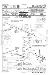
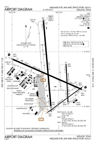


KMAF - Midland Intl Air And Space Port
Located in Midland, United States
ICAO - MAF, IATA - MAF
Data provided by AirmateGeneral information
Coordinates: N31°56'33" W102°12'7"
Elevation is 2872 feet MSL.
Magnetic variation is 09° East View others Airports in Texas
Operational data
Special qualification required
Current time UTC:
Current local time:
Weather
METAR: KMAF 162359Z 35043G60KT 7SM BKN020 14/12 A2976 RMK AO2 PK WND 36055/2358 LTG DSNT ALQDS T01390122 $
TAF: KMAF 162335Z 1700/1724 33025G35KT P6SM VCTS OVC030CB TEMPO 1700/1701 35040G60KT 2SM TSRA FM170100 35012KT P6SM SCT130 FM170600 28006KT P6SM FEW140
Communications frequencies: [VIEW]
Runways:
| RWY identifier | QFU | Length (ft) | Width (ft) | Surface | LDA (ft) |
| 04 | 54° | 4605 | 75 | ASPH | 4605 |
| 22 | 234° | 4605 | 75 | ASPH | 4605 |
| 10 | 114° | 8302 | 150 | ASPH | 8177 |
| 28 | 294° | 8302 | 150 | ASPH | 7610 |
| 16L | 177° | 4247 | 100 | ASPH | 4247 |
| 34R | 357° | 4247 | 100 | ASPH | 4247 |
| 16R | 175° | 9501 | 150 | ASPH | 9501 |
| 34L | 355° | 9501 | 150 | ASPH | 9501 |
Airport contact information
Address: Midland United States