


KLYV - Quentin Aanenson Fld
Located in Luverne, United States
ICAO - LYV, IATA -
Data provided by AirmateGeneral information
Coordinates: N43°37'0" W96°13'4"
Elevation is 1435 feet MSL.
Magnetic variation is 03° East View others Airports in Minnesota
Operational data
Special qualification required
Current time UTC:
Current local time:
Weather
METAR: KLYV 281635Z AUTO 07016KT 3SM -RA OVC007 08/07 A2977 RMK AO2 P0004
Communications frequencies: [VIEW]
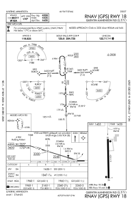
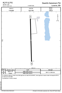
Runways:
| RWY identifier | QFU | Length (ft) | Width (ft) | Surface | LDA (ft) |
| 18 | 178° | 4200 | 75 | ASPH | |
| 36 | 358° | 4200 | 75 | ASPH |
Airport contact information
Address: Luverne United States