


KLXT - Lee's Summit Muni
Located in Lee's Summit, United States
ICAO - LXT, IATA -
Data provided by AirmateGeneral information
Coordinates: N38°57'33" W94°22'19"
Elevation is 1004 feet MSL.
Magnetic variation is 02° East View others Airports in Missouri
Operational data
Special qualification required
Current time UTC:
Current local time:
Weather
METAR: KLXT 281753Z AUTO 19015G24KT 7SM -RA SCT019 BKN026 OVC037 18/16 A2981 RMK AO2 PK WND 18027/1738 RAB40 SLP090 P0000 60001 T01830161 10194 20156 50010
Communications frequencies: [VIEW]
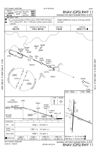
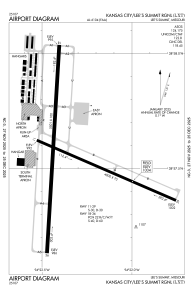
Runways:
| RWY identifier | QFU | Length (ft) | Width (ft) | Surface | LDA (ft) |
| 11 | 113° | 4000 | 75 | CONC | |
| 29 | 293° | 4000 | 75 | CONC | |
| 18 | 183° | 5501 | 100 | CONC | |
| 36 | 3° | 5501 | 100 | CONC |
Airport contact information
Address: Lee's Summit United States
