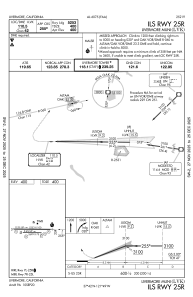
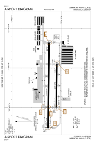


KLVK - Livermore Muni
Located in Livermore, United States
ICAO - LVK, IATA - LVK
Data provided by AirmateGeneral information
Coordinates: N37°41'36" W121°49'13"
Elevation is 399 feet MSL.
Magnetic variation is 16° East View others Airports in California
Operational data
Special qualification required
Current time UTC:
Current local time:
Weather
METAR: KLVK 251653Z 27005KT 10SM OVC020 14/09 A3009 RMK AO2 SLP187 T01390089
TAF: KLVK 251734Z 2518/2618 27008KT P6SM BKN020 BKN050 FM252100 26015G22KT P6SM SCT025 BKN050 FM260300 25012G20KT P6SM OVC020 FM261100 25009KT P6SM OVC050
Communications frequencies: [VIEW]
Runways:
| RWY identifier | QFU | Length (ft) | Width (ft) | Surface | LDA (ft) |
| 07R | 90° | 2699 | 75 | ASPH | |
| 25L | 270° | 2699 | 75 | ASPH | |
| 07L | 90° | 5253 | 100 | ASPH | |
| 25R | 270° | 5253 | 100 | ASPH |
Airport contact information
Address: Livermore United States

