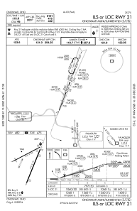
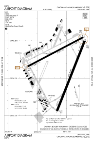


KLUK - Cincinnati Muni/Lunken Fld
Located in Cincinnati, United States
ICAO - LUK, IATA - LUK
Data provided by AirmateGeneral information
Coordinates: N39°6'12" W84°25'7"
Elevation is 483 feet MSL.
Magnetic variation is -04° East View others Airports in Ohio
Operational data
Special qualification required
Current time UTC:
Current local time:
Weather
METAR: KLUK 020253Z 00000KT 10SM CLR 18/17 A2996 RMK AO2 SLP143 T01830167 51014
TAF: KLUK 012325Z 0200/0224 25006KT P6SM SCT060 FM020100 VRB03KT P6SM SCT250 FM020700 00000KT 4SM BR SCT250 FM021300 16006KT P6SM FEW250 FM021700 19008KT P6SM SCT040
Communications frequencies: [VIEW]
Runways:
| RWY identifier | QFU | Length (ft) | Width (ft) | Surface | LDA (ft) |
| 03L | 23° | 3801 | 100 | ASPH | |
| 21R | 203° | 3801 | 100 | ASPH | |
| 03R | 21° | 6101 | 150 | ASPH | 6101 |
| 21L | 201° | 6101 | 150 | ASPH | 6101 |
| 07 | 62° | 5127 | 100 | ASPH | |
| 25 | 242° | 5127 | 100 | ASPH |
Airport contact information
Address: Cincinnati United States
