


KLTS - Altus Afb
Located in Altus, United States
ICAO - LTS, IATA - LTS
Data provided by AirmateGeneral information
Coordinates: N34°40'5" W99°16'4"
Elevation is 1382 feet MSL.
Magnetic variation is 05° East View others Airports in Oklahoma
Operational data
Special qualification required
Current time UTC:
Current local time:
Weather
METAR: KLTS 160929Z 14012KT 10SM -RA BKN047 OVC100 19/16 A2975 RMK AO2A LTG DSNT SE-S DZB0859E01RAB01E15DZB15E21RAB21 SLP060 $
TAF: TAF KLTS 160900Z 1609/1715 VRB06KT 9999 VCSH FEW060 BKN100 OVC120 510103 QNH2968INS BECMG 1609/1610 08012KT 9000 -SHRA VCTS BKN050CB QNH2975INS TEMPO 1611/1614 23018G25KT 6000 -TSRA BKN018CB BECMG 1614/1615 11012KT 9999 VCSH SCT025 BKN080 QNH2964INS TEMPO 1621/1623 12012KT 8000 -SHRA BKN060 BECMG 1622/1623 VRB06KT 9999 BKN050 QNH2968INS TEMPO 1701/1704 16012KT 8000 -SHRA BKN040 TX31/1623Z TN16/1612Z
Communications frequencies: [VIEW]
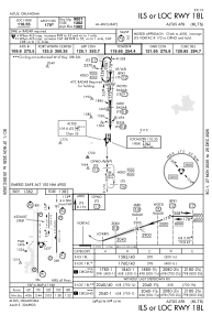
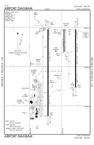
Runways:
| RWY identifier | QFU | Length (ft) | Width (ft) | Surface | LDA (ft) |
| 176 | 180° | 3500 | 90 | CONC | |
| 356 | 360° | 3500 | 90 | CONC | |
| 18L | 180° | 9001 | 150 | CONC | |
| 36R | 360° | 9001 | 150 | CONC | |
| 18R | 180° | 13440 | 150 | CONC | |
| 36L | 360° | 13440 | 150 | CONC |
Airport contact information
Address: Altus United States