


KLRF - Little Rock Afb
Located in Jacksonville, United States
ICAO - LRF, IATA - LRF
Data provided by AirmateGeneral information
Coordinates: N34°55'3" W92°8'42"
Elevation is 311 feet MSL.
Magnetic variation is -01° East View others Airports in Arkansas
Operational data
Special qualification required
Current time UTC:
Current local time:
Weather
METAR: KLRF 081055Z 11003KT 10SM OVC024 20/19 A2963 RMK AO2A DZE0955 CIG 023 RWY07 SLP033 T02020190 RVRNO $
TAF: TAF KLRF 080700Z 0807/0913 VRB06KT 9999 SCT030 QNH2960INS TEMPO 0807/0810 19035G50KT 3200 +TSRAGR OVC015CB BECMG 0812/0813 19012G20KT 9999 OVC015 QNH2962INS BECMG 0816/0817 20012G22KT 9999 BKN030 QNH2958INS BECMG 0821/0822 21015G25KT 9999 BKN050 QNH2953INS TEMPO 0902/0905 VRB20G40KT 3200 +TSRAGR OVC010CB BECMG 0907/0908 26009KT 9999 SCT025 QNH2957INS TX31/0821Z TN21/0811Z
Communications frequencies: [VIEW]
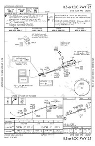
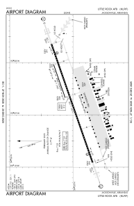
Runways:
| RWY identifier | QFU | Length (ft) | Width (ft) | Surface | LDA (ft) |
| 07 | 0° | 12007 | 150 | CONC | |
| 25 | 0° | 12007 | 150 | CONC | |
| 071 | 71° | 3499 | 60 | CONC | |
| 251 | 251° | 3499 | 60 | CONC |
Airport contact information
Address: Jacksonville United States