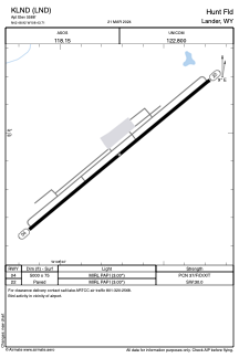


KLND - Hunt Fld
Located in Lander, United States
ICAO - LND, IATA - LND
Data provided by AirmateGeneral information
Coordinates: N42°48'55" W108°43'43"
Elevation is 5588 feet MSL.
Magnetic variation is 10° East View others Airports in Wyoming
Operational data
Special qualification required
Current time UTC:
Current local time:
Weather
METAR: KLND 211142Z AUTO 24009KT 7SM -RA FEW009 OVC022 01/00 A2994 RMK AO2 RAB00E17B39UPB37E39SNB17E37 P0006 T00110000
TAF: KLND 211122Z 2112/2212 14006KT P6SM -RA BKN005 OVC015 FM211400 02006KT P6SM -SHRA BKN018 OVC030 FM220000 25006KT P6SM SCT070
Communications frequencies: [VIEW]
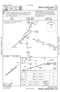
Runways:
| RWY identifier | QFU | Length (ft) | Width (ft) | Surface | LDA (ft) |
| 04 | 50° | 5000 | 75 | ASPH | |
| 22 | 230° | 5000 | 75 | ASPH |
Airport contact information
Address: Lander United States