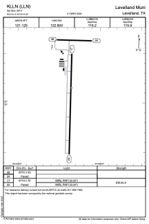


KLLN - Levelland Muni
Located in Levelland, United States
ICAO - LLN, IATA -
Data provided by AirmateGeneral information
Coordinates: N33°33'9" W102°22'21"
Elevation is 3514 feet MSL.
Magnetic variation is 09° East View others Airports in Texas
Operational data
Special qualification required
Current time UTC:
Current local time:
Weather at : KLBB - Lubbock Preston Smith Intl ( 53 km )
METAR: KLBB 280853Z 12010KT 10SM FEW100 21/17 A3001 RMK AO2 SLP103 T02110167 58002
TAF: KLBB 280540Z 2806/2906 10015KT P6SM FEW100 FM281400 16011KT P6SM SKC FM281800 15015KT P6SM FEW100 PROB30 2820/2824 5SM -TSRA SCT100CB
Communications frequencies: [VIEW]
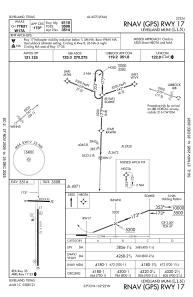
Runways:
| RWY identifier | QFU | Length (ft) | Width (ft) | Surface | LDA (ft) |
| 08 | 92° | 2072 | 55 | ASPH | |
| 26 | 272° | 2072 | 55 | ASPH | |
| 17 | 182° | 6110 | 75 | ASPH | |
| 35 | 2° | 6110 | 75 | ASPH |
Airport contact information
Address: Levelland United States