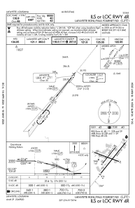
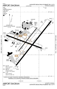


KLFT - Lafayette Rgnl/Paul Fournet Fld
Located in Lafayette, United States
ICAO - LFT, IATA - LFT
Data provided by AirmateGeneral information
Coordinates: N30°12'18" W91°59'16"
Elevation is 41 feet MSL.
Magnetic variation is 03° East View others Airports in Louisiana
Operational data
Special qualification required
Current time UTC:
Current local time:
Weather
METAR: KLFT 280453Z VRB06KT 10SM BKN024 23/21 A3000 RMK AO2 SLP158 T02330206
TAF: KLFT 272333Z 2800/2824 15017G24KT P6SM SCT040 FM281000 14018G24KT P6SM SCT015 BKN020 FM281500 15020G28KT P6SM SCT025 BKN120
Communications frequencies: [VIEW]
Runways:
| RWY identifier | QFU | Length (ft) | Width (ft) | Surface | LDA (ft) |
| 04R | 39° | 8000 | 150 | ASPH | 8000 |
| 22L | 219° | 8000 | 150 | ASPH | 7659 |
| 04L | 39° | 4099 | 75 | ASPH | 4099 |
| 22R | 219° | 4099 | 75 | ASPH | 4099 |
| 11 | 110° | 5400 | 148 | ASPH | 5401 |
| 29 | 290° | 5400 | 148 | ASPH | 5401 |
Airport contact information
Address: Lafayette United States
Other aviation service providers
Repair station

Flight schools

Acadian Aviation Pilot Training Center
Acadian Aviation Pilot Training Center
raja@kaplantel.net+1(337)291-2884