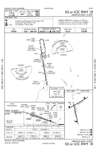
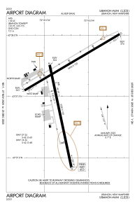


KLEB - Lebanon Muni
Located in Lebanon, United States
ICAO - LEB, IATA - LEB
Data provided by AirmateGeneral information
Coordinates: N43°37'34" W72°18'15"
Elevation is 603 feet MSL.
Magnetic variation is -16° East View others Airports in New Hampshire
Operational data
Special qualification required
Current time UTC:
Current local time:
Weather
METAR: KLEB 161353Z 30003KT 10SM FEW012 BKN060 OVC080 19/14 A2987 RMK AO2 SLP108 T01940144
TAF: KLEB 161120Z 1612/1712 03004KT P6SM FEW008 SCT025 OVC050 FM161400 03004KT P6SM SCT025 OVC040 FM161800 09005KT P6SM SCT035 BKN050 OVC070 FM170100 VRB03KT P6SM FEW008 SCT060 SCT090 FM170800 VRB03KT 3SM BR SCT004
Communications frequencies: [VIEW]
Runways:
| RWY identifier | QFU | Length (ft) | Width (ft) | Surface | LDA (ft) |
| 07 | 59° | 5496 | 100 | ASPH | |
| 25 | 239° | 5496 | 100 | ASPH | |
| 18 | 168° | 5200 | 100 | ASPH | |
| 36 | 348° | 5200 | 100 | ASPH |
Airport contact information
Address: Lebanon United States
