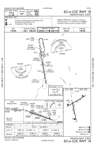
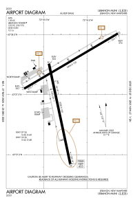


KLEB - Lebanon Muni
Located in Lebanon, United States
ICAO - LEB, IATA - LEB
Data provided by AirmateGeneral information
Coordinates: N43°37'34" W72°18'15"
Elevation is 603 feet MSL.
Magnetic variation is -16° East View others Airports in New Hampshire
Operational data
Special qualification required
Current time UTC:
Current local time:
Weather
METAR: KLEB 270453Z AUTO 00000KT 9SM FEW075 14/12 A3012 RMK AO2 SLP192 T01390122 402830139
Communications frequencies: [VIEW]
Runways:
| RWY identifier | QFU | Length (ft) | Width (ft) | Surface | LDA (ft) |
| 07 | 59° | 5496 | 100 | ASPH | |
| 25 | 239° | 5496 | 100 | ASPH | |
| 18 | 168° | 5200 | 100 | ASPH | |
| 36 | 348° | 5200 | 100 | ASPH |
Airport contact information
Address: Lebanon United States
