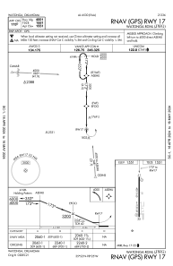


KJWG - Watonga Rgnl
Located in Watonga, United States
ICAO - JWG, IATA -
Data provided by AirmateGeneral information
Coordinates: N35°51'52" W98°25'15"
Elevation is 1551 feet MSL.
Magnetic variation is 07° East View others Airports in Oklahoma
Operational data
Special qualification required
Current time UTC:
Current local time:
Weather
METAR: KJWG 291315Z AUTO 09003KT 10SM BKN120 13/10 A2998 RMK AO2 T01300097
Communications frequencies: [VIEW]
Runways:
| RWY identifier | QFU | Length (ft) | Width (ft) | Surface | LDA (ft) |
| 17 | 180° | 4001 | 60 | ASPH | |
| 35 | 360° | 4001 | 60 | ASPH |
Airport contact information
Address: Watonga United States