


KJVL - Southern Wisconsin Rgnl
Located in Janesville, United States
ICAO - JVL, IATA - JVL
Data provided by AirmateGeneral information
Coordinates: N42°37'13" W89°2'30"
Elevation is 807 feet MSL.
Magnetic variation is -02° East View others Airports in Wisconsin
Operational data
Special qualification required
Current time UTC:
Current local time:
Weather
METAR: KJVL 211545Z 13008KT 7SM HZ BKN120 25/21 A2976
TAF: KJVL 211340Z 2114/2212 14013KT P6SM SCT035 BKN120 FM211900 16014G22KT 6SM -SHRA SCT030 BKN060 PROB30 2119/2122 5SM -TSRA BKN028CB FM212200 22014G23KT P6SM BKN050 FM220100 19015G25KT 4SM -TSRA BR BKN050CB FM220300 22015G25KT P6SM BKN025
Communications frequencies: [VIEW]
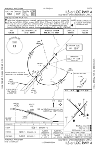
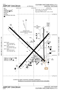
Runways:
| RWY identifier | QFU | Length (ft) | Width (ft) | Surface | LDA (ft) |
| 04 | 42° | 6701 | 150 | ASPH | 6701 |
| 22 | 222° | 6701 | 150 | ASPH | 6701 |
| 14 | 134° | 7302 | 150 | CONC | 7302 |
| 32 | 314° | 7302 | 150 | CONC | 7302 |
| 18 | 179° | 5004 | 75 | ASPH | 5004 |
| 36 | 359° | 5004 | 75 | ASPH | 5004 |
Airport contact information
Address: Janesville United States
