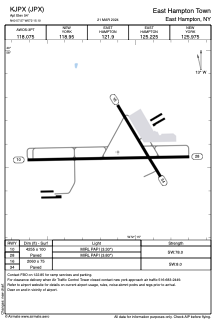


KJPX - East Hampton Town
Located in East Hampton, United States
ICAO - JPX, IATA -
Data provided by AirmateGeneral information
Coordinates: N40°57'34" W72°15'6"
Elevation is 54 feet MSL.
Magnetic variation is -13° East View others Airports in New York
Operational data
Special qualification required
Current time UTC:
Current local time:
Weather at : KMTP - Montauk ( 31 km )
METAR: KMTP 052054Z AUTO 10/07 A3026 RMK AO1 SLP245 T01000072 56017
Communications frequencies: [VIEW]
Runways:
| RWY identifier | QFU | Length (ft) | Width (ft) | Surface | LDA (ft) |
| 10 | 89° | 4255 | 100 | ASPH | |
| 28 | 269° | 4255 | 100 | ASPH | |
| 16 | 149° | 2060 | 75 | ASPH | |
| 34 | 329° | 2060 | 75 | ASPH |
Airport contact information
Address: East Hampton United States