


KJEF - Jefferson City Meml
Located in Jefferson City, United States
ICAO - JEF, IATA - JEF
Data provided by AirmateGeneral information
Coordinates: N38°35'28" W92°9'22"
Elevation is 549 feet MSL.
Magnetic variation is 03° East View others Airports in Missouri
Operational data
Special qualification required
Current time UTC:
Current local time:
Weather
METAR: KJEF 301153Z 11004KT 10SM CLR 11/11 A2994 RMK AO2 SLP127 T01110106 10139 20106 53012 $
TAF: KJEF 301120Z 3012/0112 00000KT 5SM BR SKC FM301400 17008KT P6SM SCT060 FM010500 22009KT P6SM VCSH SCT060 BKN100 FM010900 29006KT P6SM BKN120
Communications frequencies: [VIEW]
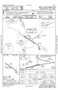
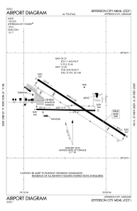
Runways:
| RWY identifier | QFU | Length (ft) | Width (ft) | Surface | LDA (ft) |
| 09 | 91° | 3401 | 75 | CONC | |
| 27 | 271° | 3401 | 75 | CONC | |
| 12 | 123° | 6000 | 100 | CONC | |
| 30 | 303° | 6000 | 100 | CONC |
Airport contact information
Address: Jefferson City United States
