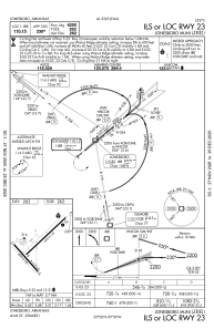
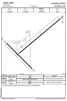


KJBR - Jonesboro Muni
Located in Jonesboro, United States
ICAO - JBR, IATA - JBR
Data provided by AirmateGeneral information
Coordinates: N35°49'54" W90°38'47"
Elevation is 262 feet MSL.
Magnetic variation is -00° East View others Airports in Arkansas
Operational data
Special qualification required
Current time UTC:
Current local time:
Weather
METAR: KJBR 082353Z AUTO 21011G20KT 7SM FEW036 BKN060 27/22 A2958 RMK AO2 SLP014 T02720222 10283 20267 55002 $
TAF: KJBR 082320Z 0900/0924 23011G20KT P6SM SCT045 BKN060 FM090200 21010KT P6SM VCTS SCT025CB BKN050 TEMPO 0902/0905 2SM TSRA BKN025CB FM090700 27008KT P6SM SCT050 BKN250 FM091200 31007KT P6SM SCT250
Communications frequencies: [VIEW]
Runways:
| RWY identifier | QFU | Length (ft) | Width (ft) | Surface | LDA (ft) |
| 05 | 50° | 6200 | 150 | ASPH | |
| 23 | 230° | 6200 | 150 | ASPH | |
| 13 | 135° | 4099 | 150 | ASPH | |
| 31 | 315° | 4099 | 150 | ASPH |
Airport contact information
Address: Jonesboro United States
