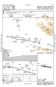


KIZA - Santa Ynez/Kunkle Fld
Located in Santa Ynez, United States
ICAO - IZA, IATA - SQA
Data provided by AirmateGeneral information
Coordinates: N34°36'25" W120°4'32"
Elevation is 674 feet MSL.
Magnetic variation is 14° East View others Airports in California
Operational data
Special qualification required
Current time UTC:
Current local time:
Weather
METAR: KIZA 161255Z AUTO 09003KT M1/4SM FG OVC002 06/06 A3007 RMK AO2
Communications frequencies: [VIEW]
Runways:
| RWY identifier | QFU | Length (ft) | Width (ft) | Surface | LDA (ft) |
| 08 | 98° | 2803 | 75 | ASPH | |
| 26 | 278° | 2803 | 75 | ASPH |
Airport contact information
Address: Santa Ynez United States