


KIPT - Williamsport Rgnl
Located in Williamsport, United States
ICAO - IPT, IATA - IPT
Data provided by AirmateGeneral information
Coordinates: N41°14'30" W76°55'19"
Elevation is 528 feet MSL.
Magnetic variation is -10° East View others Airports in Pennsylvania
Operational data
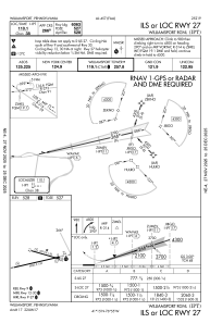
Special qualification required
Current time UTC:
Current local time:
Weather
METAR: KIPT 270554Z AUTO 18023G36KT 10SM CLR 12/M02 A3036 RMK AO2 PK WND 18036/0547 SLP279 T01171022 10161 20117 58003
TAF: KIPT 270526Z 2706/2806 17015G25KT P6SM BKN250 FM270900 09009KT P6SM OVC250 FM271400 12010G20KT P6SM BKN070 FM271600 16010G20KT P6SM -SHRA OVC035 FM271800 16010G20KT 2SM -SHRA BR OVC025 FM272100 16010G20KT 4SM BR OVC010 FM280400 10009G18KT P6SM SCT008 OVC010
Communications frequencies: [VIEW]
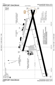
Runways:
| RWY identifier | QFU | Length (ft) | Width (ft) | Surface | LDA (ft) |
| 09 | 77° | 6825 | 150 | ASPH | 6073 |
| 27 | 257° | 6825 | 150 | ASPH | 6063 |
| 12 | 106° | 4273 | 150 | ASPH | 4273 |
| 30 | 286° | 4273 | 150 | ASPH | 4273 |
Airport contact information
Address: Williamsport United States
