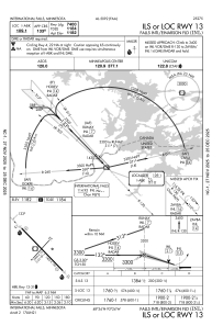
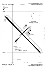


KINL - Falls Intl/Einarson Fld
Located in International Falls, United States
ICAO - INL, IATA - INL
Data provided by AirmateGeneral information
Coordinates: N48°33'56" W93°24'8"
Elevation is 1184 feet MSL.
Magnetic variation is 03° East View others Airports in Minnesota
Operational data
Special qualification required
Current time UTC:
Current local time:
Weather
METAR: KINL 070154Z AUTO 10009KT 10SM CLR 18/03 A2972 RMK AO2 SLP064 T01780033
TAF: KINL 062324Z 0700/0724 13011G20KT P6SM SKC FM071400 10018G28KT P6SM VCSH BKN060 FM071700 11019G29KT 4SM -SHRA OVC020 FM072100 11017G28KT 6SM -SHRA OVC020
Communications frequencies: [VIEW]
Runways:
| RWY identifier | QFU | Length (ft) | Width (ft) | Surface | LDA (ft) |
| 04 | 42° | 2999 | 75 | ASPH | 2999 |
| 22 | 222° | 2999 | 75 | ASPH | 2999 |
| 13 | 136° | 7400 | 150 | ASPH | 7400 |
| 31 | 316° | 7400 | 150 | ASPH | 7400 |
Airport contact information
Address: International Falls United States