


KIDA - Idaho Falls Rgnl
Located in Idaho Falls, United States
ICAO - IDA, IATA - IDA
Data provided by AirmateGeneral information
Coordinates: N43°30'49" W112°4'15"
Elevation is 4743 feet MSL.
Magnetic variation is 12° East View others Airports in Idaho
Operational data
Special qualification required
Current time UTC:
Current local time:
Weather
METAR: KIDA 082153Z 36010KT 10SM -RA SCT031 OVC043 08/02 A3007 RMK AO2 RAB18 SLP183 P0000 T00830017
TAF: KIDA 081738Z 0818/0918 21013G23KT P6SM VCSH BKN050 BKN080 FM082000 35013G23KT P6SM VCSH BKN050 BKN080 FM090600 01010G18KT P6SM SCT070
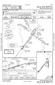
Communications frequencies: [VIEW]
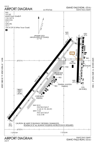
Runways:
| RWY identifier | QFU | Length (ft) | Width (ft) | Surface | LDA (ft) |
| 03 | 38° | 9002 | 150 | ASPH | 9002 |
| 21 | 218° | 9002 | 150 | ASPH | 9002 |
| 17 | 182° | 3964 | 75 | ASPH | |
| 35 | 2° | 3964 | 75 | ASPH |
Airport contact information
Address: Idaho Falls United States

