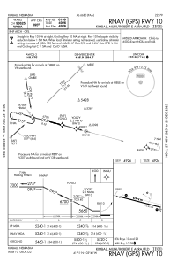
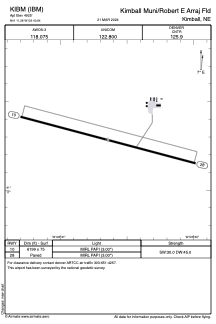


KIBM - Kimball Muni/Robert E Arraj Fld
Located in Kimball, United States
ICAO - IBM, IATA -
Data provided by AirmateGeneral information
Coordinates: N41°11'17" W103°40'39"
Elevation is 4925 feet MSL.
Magnetic variation is 10° East View others Airports in Nebraska
Operational data
Special qualification required
Current time UTC:
Current local time:
Weather
METAR: KIBM 211835Z AUTO 35016G22KT 10SM SCT031 14/04 A2987 RMK AO2 T01370044
Communications frequencies: [VIEW]
Runways:
| RWY identifier | QFU | Length (ft) | Width (ft) | Surface | LDA (ft) |
| 10 | 105° | 6199 | 75 | CONC | |
| 28 | 285° | 6199 | 75 | CONC |
Airport contact information
Address: Kimball United States