


KIAH - George Bush Intcntl/Houston
Situé à Houston, United States
ICAO - IAH, IATA - IAH
Données fournies par AirmateInformation générale
Coordonnées: N29°59'4" W95°20'29"
Élévation : 95 feet MSL.
Variation magnétique : 03° East Voir autres Aéroports à Texas
Données opérationnelles
Special qualification required
Heure actuelle UTC:
Heure actuelle locale:
Météo
METAR: KIAH 131253Z 00000KT 2SM BR FEW002 BKN018 OVC028 25/24 A2975 RMK AO2 SLP072 T02500244
TAF: KIAH 131257Z 1313/1418 VRB04KT 6SM BR SCT007 BKN025 TEMPO 1313/1314 2SM BR FM131800 20008KT P6SM VCTS BKN040CB TEMPO 1319/1323 VRB20G30KT 3SM TSRA BR FM132300 32008KT 6SM SHRA BR VCTS BKN040CB FM140200 VRB05KT 5SM BR SCT025 FM141400 31006KT P6SM FEW025
Fréquences de communication: [VIEW]
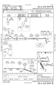
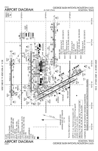
Pistes:
| Identifiant RWY | QFU | Longueur (ft) | Largeur (ft) | Surface | LDA (ft) |
| 08L | 90° | 9000 | 150 | CONC | 9000 |
| 26R | 270° | 9000 | 150 | CONC | 9000 |
| 08R | 90° | 9402 | 150 | CONC | 9402 |
| 26L | 270° | 9402 | 150 | CONC | 9402 |
| 09 | 90° | 10000 | 150 | CONC | 10000 |
| 27 | 270° | 10000 | 150 | CONC | 10000 |
| 15L | 152° | 12001 | 150 | CONC | 12001 |
| 33R | 332° | 12001 | 150 | CONC | 12001 |
| 15R | 152° | 10000 | 150 | CONC | 10000 |
| 33L | 332° | 10000 | 150 | CONC | 10000 |
Coordonnées de l'aéroport
Adresse: Houston United States