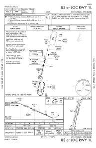
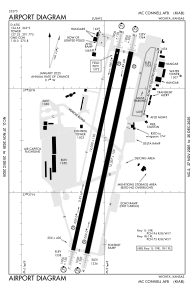


KIAB - Mc Connell Afb
Located in Wichita, United States
ICAO - IAB, IATA - IAB
Data provided by AirmateGeneral information
Coordinates: N37°37'23" W97°16'3"
Elevation is 1371 feet MSL.
Magnetic variation is 04° East View others Airports in Kansas
Operational data
Special qualification required
Current time UTC:
Current local time:
Weather
METAR: KIAB 052055Z AUTO 11011KT 10SM CLR 20/15 A2992 RMK AO2 SLP129 T01980146 57026 $
TAF: TAF KIAB 051800Z 0518/0624 09009KT 8000 -RA BKN008 QNH2997INS BECMG 0520/0521 11009KT 9999 NSW BKN019 OVC026 510653 QNH2983INS BECMG 0602/0603 11006KT 8000 BR OVC006 QNH2981INS BECMG 0618/0619 16012G18KT 8000 BR BKN016 510053 QNH2967INS BECMG 0622/0623 17020G25KT 9000 -SHRA BKN023 OVC030 QNH2952INS TEMPO 0623/0700 VRB35G45KT 4800 TSRA BKN015CB OVC030 TX20/0618Z TN15/0518Z
Communications frequencies: [VIEW]
Runways:
| RWY identifier | QFU | Length (ft) | Width (ft) | Surface | LDA (ft) |
| 01L | 12° | 12000 | 150 | OTHER | |
| 19R | 192° | 12000 | 150 | OTHER | |
| 01R | 12° | 12007 | 150 | ASPH | |
| 19L | 192° | 12007 | 150 | ASPH |
Airport contact information
Address: Wichita United States