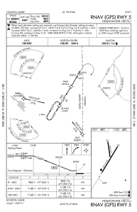
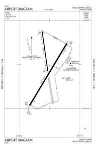


KHUL - Houlton Intl
Located in Houlton, United States
ICAO - HUL, IATA - HUL
Data provided by AirmateGeneral information
Coordinates: N46°7'29" W67°47'32"
Elevation is 489 feet MSL.
Magnetic variation is -18° East View others Airports in Maine
Operational data
Special qualification required
Current time UTC:
Current local time:
Weather
METAR: KHUL 271153Z AUTO 00000KT 10SM CLR 03/M05 A3049 RMK AO2 SLP330 T00331050 10033 21056 52014 $
TAF: KHUL 271120Z 2712/2812 VRB03KT P6SM SKC FM272200 16005KT P6SM FEW250 FM281100 18005KT P6SM SCT250
Communications frequencies: [VIEW]
Runways:
| RWY identifier | QFU | Length (ft) | Width (ft) | Surface | LDA (ft) |
| 01 | 352° | 2700 | 60 | ASPH | |
| 19 | 172° | 2700 | 60 | ASPH | |
| 05 | 31° | 5015 | 100 | ASPH | |
| 23 | 211° | 5015 | 100 | ASPH |
Airport contact information
Address: Houlton United States